A memorial to Hannaford and other Cincinnati architects would help Cincinnatians remember our unique history as buildings on the American landscape homogenize around us.
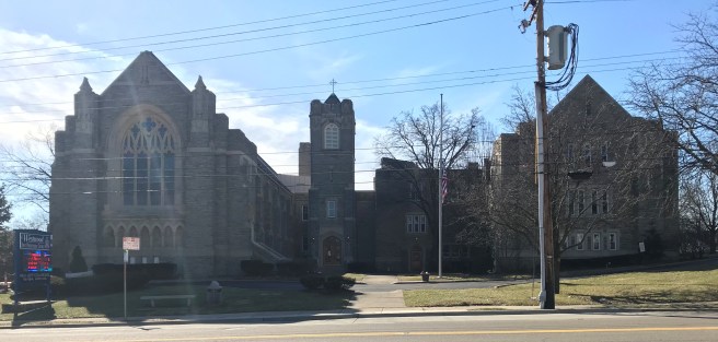
On the corner of Epworth and Urwiler Avenues in the heart of Westwood stands Westwood United Methodist Church. The historic church was built in 1896. It was designed by a man who is remembered as Cincinnati’s most famous architect, Samuel Hannaford.
Westwood United Methodist Church
Some 40 years before the completion of the Westwood church, a young Hannaford at the start of his career perhaps could have been observed walking past this site, traveling on weekends from his downtown boarding room to the home of his wife’s family in the Cheviot area (present day Westwood.) Hannaford had arrived in the United States with his parents and seven siblings as a nine year old immigrant from England; his father purchased a farm soon after arriving. This 1847 Hamilton County map shows the Hannaford home along Harrison Avenue in what is now Westwood. Samuel started apprenticing as an architect in 1854 and in 1857 married Phoebe Stathem, who was from a family of early Cheviot pioneers. Present day Stathem Avenue in Westwood is a block from Westwood United Methodist church.
As an architect, Hannaford had stints where he formed partnerships with architects Edwin Anderson and Edwin Proctor, as well practicing solo, before founding the firm of Hannaford and Sons, which survived him for many years posthumously after his death in 1911. Over the course of his career, he designed City Hall and Music Hall, as well as other churches, schools, lodges, and residences throughout the Cincinnati area, too numerous to list here. You can read more about the life of Samuel Hannaford at Betty Ann Smiddy’s excellent website here (which was used as a primary reference source for this post) and see a list of works on the same website here.
Besides the Westwood United Methodist Church, Hannaford and the firm of Hannaford and Sons had their hand in many buildings in Westwood. The Cheviot Masonic Lodge at the corner of Harrison & Montclair was completed in 1910. The beautiful Mother of Mercy High School on Werk Road was completed in 1922. Westwood First Presbyterian Church, a landmark on Harrison Avenue, was completed in 1926.
Cheviot Masonic Lodge by Hannaford and Sons, now used as a community center.Mother of Mercy High School, designed by Hannaford and Sons, has been purchased by Cincinnati Public Schools. Public engagement about future plans for the building are ongoing.Westwood First Presbyterian Church designed by Hannaford and Sons
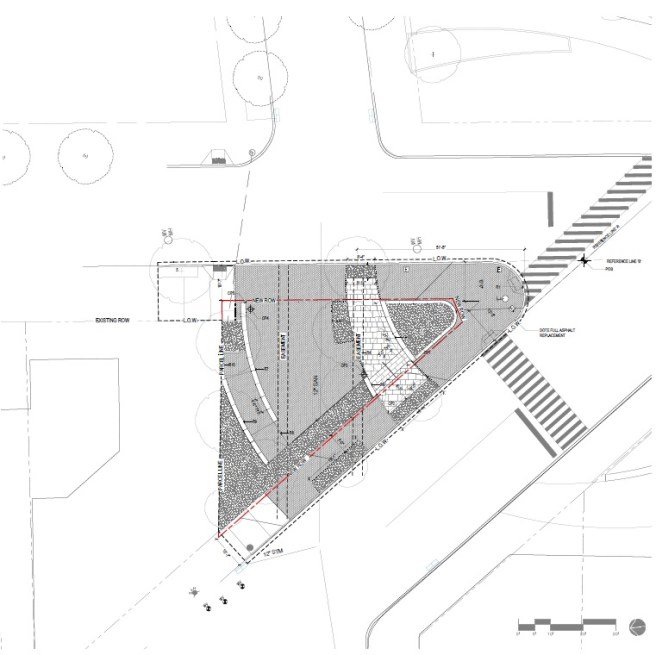
This year, 2019, the grounds of Westwood Town Hall are being renovated. Gaines Triangle, a small strip on land between Harrison and Epworth across from Westwood United Methodist Church, is part of the project. I submit that this would be a good location for a Samuel Hannaford memorial of some kind, one that would engage the passing pedestrian walking through Westwood’s neighborhood business district.
Gaines Triangle Layout Plan, by MKSK
A memorial here could take many forms, depending on community input and support. Perhaps there could be a statue of a seated Hannaford working at a desk, facing the church he designed. Perhaps human-sized sculptures of architectural trade tools from Hannaford’s period could be constructed, that people could climb on and pose with for social media posts. Perhaps there could an interactive electronic kiosk of some kind. Perhaps a bust or an Ohio Historical Marker would be appropriate.
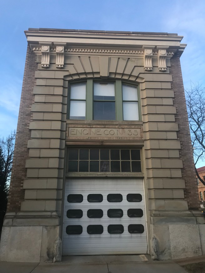
Gaines Triangle also sits across the street from the landmark Cincinnati and Suburban Bell Telephone Building that has recently been rehabbed into a new home for Madcap Productions Puppet Theatre.This gorgeous building is not a Hannaford, but was designed by another very prominent Cincinnati architect, Harry Hake. Hake designed many police and fire stations across Cincinnati, including the Junietta Firehouse (built 1907) in Westwood, just across Harrison Avenue from the telephone exchange building. He also designedthe Art Deco-style Cincinnati Bell building on Seventh Street, as well as other buildings downtown, and founded a long lasting architectural firm. Perhaps the concept of a Hannaford memorial could be expanded to tell the story of Hake or other Cincinnati architects.
Cincinnati and Suburban Bell Telephone Building by Harry HakeJunietta Firehouse by Harry Hake
Why is it important, for us as Cincinnatians, to care about these old buildings and the people that built them? The Cincinnati of the past, that built these buildings, used to be a big and important city, with much more national cultural relevance than it has today. But decisions we have made in the modern era- bulldozing the dense neighborhoods of the West End for highways, tearing down our architectural heritage for parking lots- have mutilated our urban form and have exacerbated, if not caused, our relative decline. When developers today try to build “work-live-play environments” to “attract millennial talent”, what they are trying to do is (often clumsily) build an imitation of the traditional city. Fortunately for us, Cincinnati still has intact portions of the real thing. This is our “brand”, our competitive advantage, and the key to our future success.
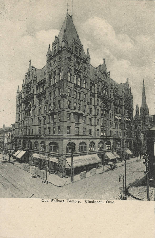
Odd Fellows Temple, built in 1894, was another Samuel Hannaford creation that sat at the northwest corner of Seventh and Elm downtown. It was torn down and replaced with a parking garage. Image source: Cincinnati Public Library
While Metro absolutely needs new and increased funding to maintain and improve service, there is one way to improve service that wouldn’t increase their operating costs.
Metro was formed in 1973 to operate Cincinnati’s bus system by the Southwest Ohio Regional Transit Authority (SORTA, an agency of the state of Ohio) and the City of Cincinnati. It is funded by a 0.3% City of Cincinnati income tax, paid by those who live and/or work in the city. A Hamilton County-wide source of funding for Metro has never materialized in the many decades since its founding, even though Metro continues to provide transit service beyond the city limits. This is a uniquely one-sided arrangement that is not found in peer cities across the country, and is not providing Metro with the funds required to maintain its existing fleet and level of service, let alone to improve it. In 2018, Metro will again put a sales tax proposal in front of county voters.
Beyond the funding they receive from the city, however, Metro seems to be disconnected from City Hall. Public transit, and how it can serve, spur, and soften the impact of development, is an afterthought at best in city’s planning decisions. The bus system has hardly any built infrastructure besides the hub at Government Square. We are failing at providing bus shelters. But the largest disconnect is paved into the roads and streets themselves. It’s taken as a given that our roads and streets should maximize throughput of private vehicles, and no special accommodation is given to public transit, especially where it may compromise this goal. This is a value judgement, a statement of priorities, that needs to be revisited. Ultimately we need to reverse course and install transit-only lanes to keep our transit system moving along strategic corridors city-wide.
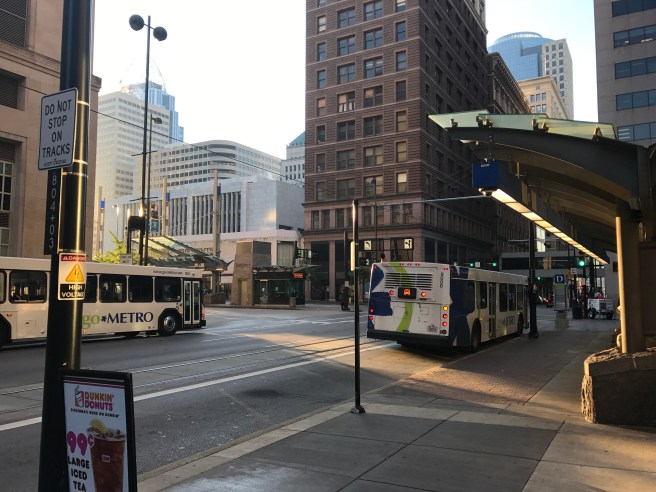
No special accommodations are made on Walnut Street for transit vehicles approaching Government Square, the region’s main transit hub. (Thankfully these buses were not stuck in traffic at the time of this picture.)
What transit-only lanes can provide
By giving transit vehicles exclusive lanes, intuitively, their speed and reliability are increased. They are more able to meet a regular schedule no matter what congestion chaos is unfolding around them. This has far reaching implications. By increasing a transit vehicle’s average speed, the vehicle can now make more trips along a given route in a given period of time. Frequency of service is thus increased, and headways, the amount of time the transit rider must wait at a stop in between vehicle arrival, go down. This increases the overall quality of service without incurring the extra expense and costs of adding vehicles into service.
Transit-only lanes are not radical
In her book Streetfight, former NYC Transportation Commissioner Janette Sadik-Khan describes installing bus lanes on 34th Street in Midtown Manhattan. 34th Street is one of Manhattan’s busiest streets, linking the Queens-Midtown Tunnel to the Lincoln Tunnel, and passing by the Empire State Building as well as very close to Penn Station. In Seattle, Third Avenue becomes a transit-only corridor during rush hour. Small and mid-sized cities have installed transit-only lanes as well. Grand Rapids has installed the Silver Linebus rapid transit (BRT) that features dedicated lanes on a long corridor leading into downtown. Pittsburgh has a counter-traffic flow bus lane on Fifth Avenue, a main corridor in the neighborhood of Carnegie Mellon University and the University of Pittsburgh. They are also testing out bus lanes downtown.
Bus lane near the University of Pittsburgh Medical Center.Transit-only lanes are fair
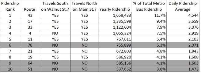
In Cincinnati, two obvious candidates for receiving transit-only lanes are Walnut and Main through the Central Business District (CBD,) especially in the vicinity of the main bus hub, Government Square. My analysis of ridership data obtained from the recent SORTA Service Evaluation, Development, and Management Study shows that about 74% of Metro’s total bus ridership uses routes that are routed along Walnut or Main streets in this area. This is about 10.4 million riders annually, or a daily average of about 28,560, not considering variation in the weekday vs. weekend ridership. (The daily average breakdown is about 22.2k for routes that utilize Walnut, about 24.9k for routes that utilize Main, and about 28.6k for routes that utilize either Walnut OR Main.) The streetcar, also traveling these corridors, had 700,000+ riders, with a daily average of about 2,000, in its first year. It’s important to note thatnot every rider on these routes physically travels down Walnut or up Main; they may board and disembark elsewhere on the route, outside of the downtown area altogether. To obtain the specific number of riders present on Walnut or Main in this corridor would require another level of analysis. However, it is fair to say that every rider on the route is negatively affected if their transit vehicle is held up in traffic there.
This table examines the top ten Metro bus routes by ridership. Seven out of the ten routes are routed on Main or Walnut streets in the area of Government Square.
Meanwhile, the number of data points on OKI’s website giving traffic counts for Walnut and Main Streets in the neighborhood of Government Square is surprisingly few, and the data is dated. At the closest data point, the AADT (average annual daily traffic) for Main Street at Fourth Street is 6,250, last recorded in 2006. According to USDOT, average vehicle occupancy is about 1.6 persons per vehicle, and multiplying that by the Main Street vehicle count yields a very rough estimate of 10,000 people traveling by private vehicle. In contrast, an aforementioned daily average of about 24,870 people use bus routes that are routed on Main in the vicinity of Government Square, that have the potential to be affected by a traffic jam there.
Public transit vehicles are high-occupancy vehicles compared to cars, and a transit-only lane can end up moving more people through the city than a traffic lane can, even if it seems like there’s not always a bus going by. To quote transit expert Jarrett Walker from his book Human Transit:
Once you decide that your streets are designed for people movement rather than vehicle movement, turning car lanes into transit lanes not only is fair but is also the most effective way to maximize the total number of people who can move along the street. And if you want to grow your economy without growing congestion, that’s the output you need to focus on.
We need transit-only lanes
Two weeks ago, something magical happened- the vision for a four day light and art festival, BLINK, became reality and drew a million people to the streets and sidewalks of downtown and Over the Rhine. The event was partially inspired by the streetcar, with installations located up and down its route. Streetcars were packed like sardine cans. The streetcar did indeed have better than average ridership numbers for the weekend- but they were nowhere close to what they could have been. That is because the streetcar was stuck in gridlocked traffic, taking a ridiculous amount of time to complete its loop. The gridlock also caused incredible disruption to the Metro bus system, greatly inconveniencing regular Metro bus riders, and hindering the ability to bring visitors in and out of downtown by bus. If Cincinnati wants to have its circulatory system up and functioning during world class events like BLINK or a national political convention, it needs dedicated lanes for transit: permanent wherever possible, and temporary where they can not be permanent.
A full streetcar struggles through traffic to a full station platform during Cincinnati’s BLINK festival.Finally, transit-only lanes could be potent tools to help us build a more equitable city. Many transit riders are hourly wage workers that cannot afford to be late due to unexpected delays in their commute. A more reliable transit system is a must for them. There is the human factor to consider- the value of a parent’s time to be able to prepare a meal or help their children with homework in the evening. This also can be facilitated by a faster and more reliable transit system.
Expanded investment in Metro is critical, and Metro also needs to work with the city’s Department of Transportation and Engineering to make sure vehicles are efficiently moving along their routes. A key part of that is transit-only lanes.
Thanks to Cam Hardy and the Better Bus Coalition for sharing the bus ridership data used in this post.
This post has been edited for clarity from its original version.
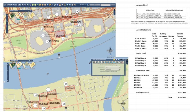
Cincinnati needs to work together with Covington, Kentucky to assemble an urban campus for Amazon by the banks of the Ohio River.
In a move that set cities across the nation buzzing, Amazon recently put out a Request for Proposal to build a second corporate headquarters in North America. The numbers being thrown about are astounding- 50,000 new full time employees averaging over $100k a year in compensation, over $5 billion in capital investment, potential demand for up to 8 million square feet of office space. This project would promise to turn around any city struggling from lackluster demand in a hurry, and send plans for growth into fast forward.
Though not at the top of the list of many pundits discussing the matter, Cincinnati can put together an appealing bid for Amazon. Here’s how.
We have the urban space
How Amazon HQ2 could fit on both sides of the Ohio River. The Banks project needs a catalyst to drive it to completion; the Fort Washington Way highway caps remain an item on Hamilton County’s wish list; Covington’s IRS site will be an enormous plot of land in need of redevelopment in coming years.
The Banks neighborhood of downtown Cincinnati, located in between two professional sports stadiums and home to the National Underground Railroad Freedom Center, has been gradually filling in since 2007. It scored some major wins with the opening of the gorgeous Smale Riverfront Park in 2015 and the opening of the GE Global Operations Center in 2016. Development on each block of the Banks requires the build out of a parking garage podium up to street level to keep buildings out of the flood plain. The resulting garage, when completed, will have 8,000 spaces and be one of the largest contiguous parking facilities in the nation.
The Banks has space remaining to accommodate Amazon’s Phase 1 requirements of 500,000 to 1,000,000 square feet. Additionally, Amazon is precisely the type of high-value end user the Banks needs in order to justify the costs of building out the remaining parking garages.
Just to the north of the Banks lies Fort Washington Way, a highway cutting across downtown that was wisely routed into a trench as part of a major construction project that finished in the year 2000. Since then, it has been the dream of many to cap the highway in order to bridge the gap between the Banks and the rest of downtown. The costs involved have kept this just a dream; the cost of a single deck could be $25 million.
Building office buildings upon the highway decks could make sense for Amazon, however, even if it would not for another user. It would provide Amazon with the ability to expand their square footage incrementally, and in close proximity to the other potential buildings at the Banks. The decks, along with other buildings at the Banks, could very nearly provide the required space to meet Amazon’s Phase 2 needs of 1,000,000 to 2,000,000 square feet.
South of the river in Covington, just over the historic Roebling Suspension Bridge, lies a huge redevelopment opportunity. Many years ago in a different era, the IRS constructed a squat, sprawling 1 story office building that takes up about as much land as Paul Brown Stadium. The IRS now plans to vacate this site by 2019; the closure represents a huge number of jobs lost for Covington, but also provides the opportunity to redevelop and densify a huge expanse of prime downtown land, as well as reconnect the street grid through the site.
The IRS site could provide the square footage required for Amazon’s enormous Phase 3 requirements of 2,000,000 to 3,000,000 square feet. Amazon’s project phasing, with the final phase requiring the most space, works out well because this site, the largest we have to offer, will not be available until 2019 or later. Landing Amazon would soften the blow to Covington of losing the IRS jobs.
Only an urban core location will do
Images from Amazon’s South Lake Union neighborhood in Seattle, March of 2015. Construction cranes were everywhere as a walkable urban district was taking shape, served by streetcar.
The RFP says that both urban or suburban options will be considered, but also asks for a proposal that is a good cultural fit for Amazon. In Seattle, Amazon occupies many buildings in the South Lake Union neighborhood, in between downtown Seattle and the shores of Lake Union. There are plenty of urban amenities like parks and restaurants, all within walking distance of the front doors of their office buildings. South Lake Union is also well connected with nearby neighborhoods and other parts of the city via transit. In our region, only a location in the urban core can provide a comparable experience at the necessary scale for Amazon.
A development in Amazon’s South Lake Union neighborhood in Seattle touts its Walk Score.
In fact, the RFP specifically asks for transit, walking, and biking amenities that are only available in our core:
Be sure to include opportunities to cultivate local culture and creativity into the Amazon HQ2 site. Also, include connectivity options: sidewalks, bike lanes, trams, metro, bus, light rail, train, and additional creative options to foster connectivity between buildings/facilities.
A location in the urban core supplies the most items on this list. Downtown Cincinnati and Northern Kentucky’s river cities are eminently walkable. The Metro and TANK bus systems offer their highest level of service in this area. The streetcar connects the Banks to the exciting cultural and dining destinations of Over the Rhine. Redbike stations are plentiful on both sides of the river.
It’s also useful to think of future connectivity options for a campus at the Banks/along the Covington riverfront as well. Bike trailsspanning the East and West Sides are planned along the Ohio River that will converge at the Banks (and also connect to larger trail network.) A cycletrack could be built downtown that connects to the Central Parkway bike lanes which could then be extended all the way to Northside. The Cincinnati streetcar may someday be expanded to Covington and Newport. The Riverfront Transit Center underneath Second Street may someday house light rail to our international airport CVG, and/or have a larger role in our bus system. The urban core will always naturally have the most connectivity in our region.
Two states are better than one
Amazon didn’t mince words in their RFP: they are looking for incentives. In this realm, having the HQ2 campus span two states is a decided advantage. Two states can offer more incentives than one state can, while at the same time mitigating their cost and risk.
Beyond incentives, let’s take a look at what Amazon is seeking to accomplish. Creating a second corporate headquarters is an unconventional move. One goal may be to curry more favor in the political realm by expanding their footprint and providing jobs in a wider variety of states and localities. If Amazon established a campus spanning the Ohio River (with all buildings still within a walkable and bikeable distance,) they would be firmly establishing their interests in two states with one action.
It could happen
Blocks available for development at the Banks (as seen from Paul Brown Stadium)
And so, Cincinnati’s long shot bid may not be such a long shot after all. At the very least, this experience should be a drill to get our officials to act cooperatively and make an in-depth evaluation of our region’s assets and potential. It should also be a wake-up call that makes them realize that tech companies seeking top talent do not only value, but expect, a strong transit system, walkability, and bike infrastructure.
Cincinnati’s newest apartment tower under construction at Eighth and Sycamore.
With the introduction of the streetcar, eastern Downtown Cincinnati is primed for growth. But as always in a city like ours that has lived through the misnamed “urban renewal” era, several changes could be made to transform it into a more welcoming urban environment.
For this discussion, eastern Downtown will mean everything east of Main Street to the foot of Mt. Adams, in between the river and Pendleton. This area is characterized by Sycamore and Broadway, which are two typical north-south CBD streets, and Eggleston, a boulevard-like avenue which runs at an angle, providing a shortcut between the riverfront and OTR. There are several sub-districts of this area, each with their own defining characteristics: Sawyer Point, the “Financial District”, the Lytle Park area, the valley of the parking lots (appropriately home to “Culvert Street”), the Main Street Historic District, and the Courthouse and Casino areas.
The Valley of the Parking Lots could be redeveloped to add many residents to the area.
Besides the streetcar, there’s a lot of things going on in the neighborhood. A new bike and jog path along Eggleston has opened. Construction continues on theEighth and Sycamore apartment tower, and a new tower including a Kroger grocery store is proposed just to the west at Court and Walnut. On the negative side of the ledger, in a blow to historic preservation efforts, the old Dennison hotel has recently been razed instead of rehabbed. What could have been a nice momentum boost, adding 50 or so residential units if the building was rehabilitated, instead turned into a debacle directly contradicting Downtown’s narrative of progress.
New shared use bike and jog path along Eggleston
So, without further ado, here’s some ideas for eastern Downtown:
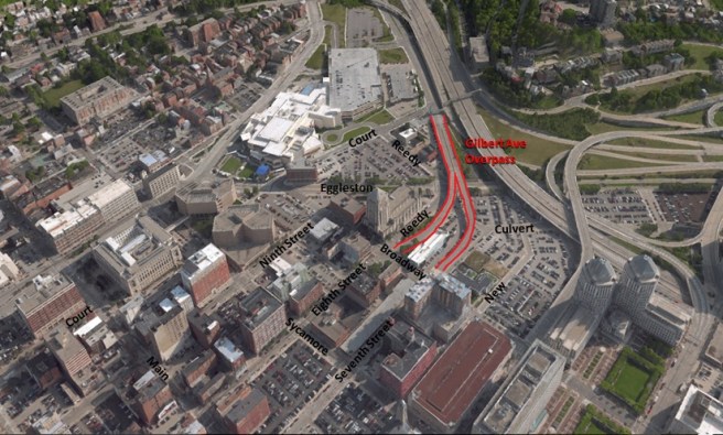
Remove the Gilbert Avenue Overpasses
Gilbert Avenue, which is the main thoroughfare from Walnut Hills to Downtown and also connects to I-71, abandons its terrestrial confines south of Court Street to form an overpass over Eggleston Avenue that connects directly to Seventh and Eighth Streets. The purpose of this overpass is to give east-west traffic downtown slightly faster access to and from I-71.
However, there were three negative tradeoffs made to accomplish this. First, the overpasses take up valuable land, that if built upon, could otherwise contribute to the vibrancy of the city as well as to its tax rolls. Second, the overpasses cost money to maintain, and indeed look like they are due for maintenance soon. Third, the overpasses themselves encourage cars to speed on their way in and out of town, decreasing the quality of life on the surrounding streets and endangering pedestrians.
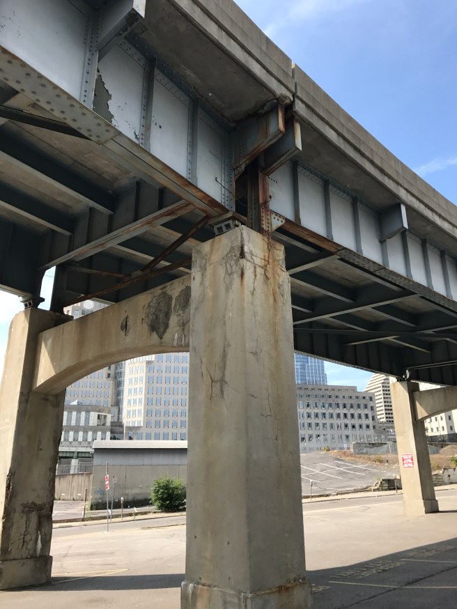
Underside of Gilbert Avenue overpass
In my opinion, the extra seconds shaved from a commute time by the overpasses are not worth the costs of these tradeoffs. The overpasses should be removed, and Gilbert Avenue should become a surface street that forms an intersection (or even a roundabout) with Eggleston. Gilbert can run where Reedy Street is now between Eggleston and Broadway, and then connect to/become Eighth Street. The former overpass land can be made available for development.
Convert One Way Streets to Two Way
Another traffic-related issue is the prevalence of one way streets in the area. One way streets are meant to increase traffic throughput, but also come with tradeoffs that may not be worth it. They can make an area more complicated to navigate. Without the psychological effect of oncoming traffic, people are more likely to speed on a one way street. One Louisville study found that converting one way streets to two way decreased traffic accidents, and even had second hand effects like decreased crime and increased property values. Two way streets have also been shown to be more productive in driving business to storefronts.
Eighth Street is a two way street through the middle of downtown, in between 9th Street to the north, which is one way westbound, and 7th Street to the south, which is one way eastbound. (In other words, 7th and 9th form the pair of one-way streets in this area.) However, east of Main Street, Eighth Street is one way westbound. This complicates navigation of the area, and increases speeds of cars coming in from the Gilbert Ave. overpass. Eighth Street can be made into a two way street here. Additionally, Broadway is a two way street between Third and Fifth Streets, before becoming a one way northbound street north of Fifth. It can also be converted to two way for its entire length to increase the navigability of the area.
Move the Jail
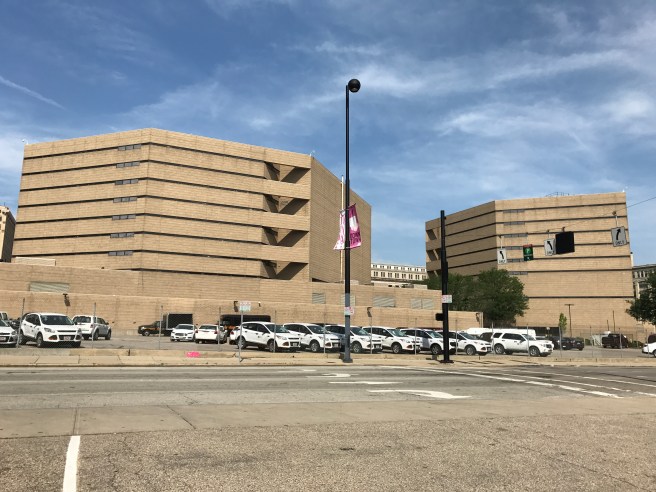
Hamilton County Justice Center
Hamilton County is a major presence in eastern downtown. In addition to the Courthouse and Justice Center (Jail,) they have offices spread out among 4 other buildings in the area. The Justice Center, built in 1985, has had issues with overcrowding for years nowthat continue to the current day, and sales tax ballot measures to fund a replacement failed at the ballot box in 2006 and 2007. In the context of the neighborhood, the Justice Center now sits on valuable land across the street from the Casino (built in 2013) and across Central Parkway from the resurgent Pendleton neighborhood. But one could argue that the Justice Center, an eyesore, is an impediment to development on the immediate neighboring downtown blocks that would otherwise be quite desirable.
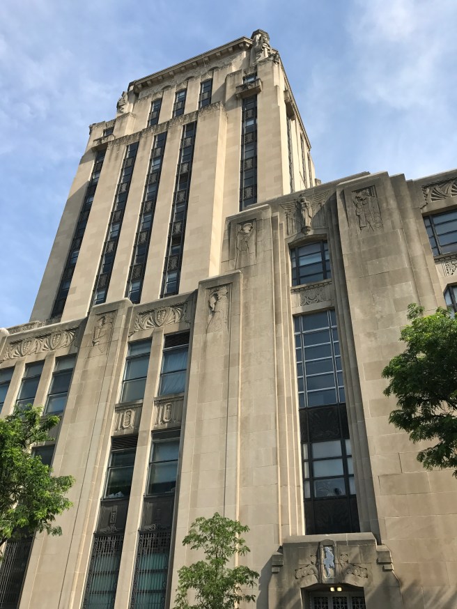
The Times-Star Building, owned by Hamilton County
Hamilton County should build a new, modern jail outside of downtown (in a transit-accessible location,) and consolidate all services and offices into a new office tower to be constructed where the north building of the Justice Center now stands. This would set up a one-stop, transit-accessible shop downtown for citizens utilizing county services, and could lead to efficiencies in the budget. This would also allow the buildings the County now owns, which are attractive and historic, to be renovated into residential structures, increasing the population of the neighborhood.
Build at the base of the Purple People Bridge
Recently “Aqua on the Levee,” a 239 unit apartment complex, opened on the Newport side of the Purple People Bridge, alongside an Aloft Hotel. Yet the Cincinnati side of the bridge has little development on the streets surrounding it, despite the presence of the wonderful Sawyer Point park. “Skyhouse,” a 352 unit apartment tower, was proposed for this location, but encountered difficulties in financing. The project isstill in negotiations, one discussion point being the possibility that the garage originally proposed for this project become a public asset.
Newport side of Purple People Bridge (top) compared to Cincinnati side (bottom.)
If public support is given to the garage, it should be designed in such a manner that it could be shared with future development on other nearby lots. The city could even develop on the Sawyer Point park parking lot. A master plan could be created for the immediate area, with the goal of adding 1,000 to 2,000 residents. Alongside the park and river and surrounded by urban amenities, this is a desirable location for people to live.
Extra Credit
I put a lot of ideas and concepts on this blog, and one thing I could be better at is explaining the relative priority and practicality of them. Realistically, I think Cincinnati’s priority should be growth through adding residents, as detailed in my post Cincinnati Needs People(and preferably by spurring organic growth that doesn’t require a large amount of intervention by public entities.) On the other hand, one post I’ve made on this blog that is more pie-in-the-sky is the idea for a Mt. Adams Gondola, an air tram that could lift people directly from the vicinity of 7th or 8th Street up to Eden Park and the Mt. Adams Business District. I still think such an attraction would be immensely popular with tourists. However, in considering a gondola as a form of transit, I think we have the obligation to improve our bus system first, which serves thousands of people each day.
Another “big idea” for eastern Downtown concerns the future of US Bank Arena. Again, I think our priority should be on population growth, but the options here can be interesting to think about. There is a proposal by the owners of the arena to rebuild the arena in its current location. In a different scenario, if the arena is torn down for good, a residential tower could be built along the riverfront in its place. Constructing a new arena near the Casino has been suggested by the website UrbanCincy.
Note: Several of these concepts have been discussed in various forms on websites such as UrbanCincy and UrbanOhio. In this blog post, my intent is not to take credit for the originality of these ideas, but instead to consolidate and elaborate on them.
Cincinnati needs to transform itself by adding 10,000 people to the core neighborhoods of the CBD, OTR, Pendleton and the West End.
A graphic from the 1890 Census shows American cities ranked by population at each 10 year census interval. The graph begins on the right side in 1790 and proceeds to the left. Cincinnati appears in 1820 and reaches a rank of #6 in the 1840 and 1850 Censuses. Cincinnati ranked #65 after the 2010 Census.
When I was a kid and my family went on vacation, we always got the Trip Tik travel guides from Triple A. I would study them in the backseat to pass the time. Included in the guides were city descriptions, with population numbers. I always felt like my hometown of Cincinnati was a big and important city, but… these numbers told a story I didn’t quite want to hear. The population of Cincinnati city proper just was not that much compared to other cities.
Fast forward to the most recent census in 2010, and Cincinnati’s total population stands at 296,943. That is down from an all time high of 503,998 in 1950. One hundred years prior to that, in 1850, there were as many as 43,000 people living in Over the Rhine alone. Today the population of Downtown, Over the Rhine, and Pendleton combined is 13,521, according to a 2013 DCI estimate.
Now obviously, a return to the tenement-style densities of the old Over the Rhine is no longer possible, or desirable. But a goal of adding at least 10,000 people to Cincinnati’s core “basin” neighborhoods, over the course of the next decade, is both possible and desirable. There are many benefits to doing so, but there are also many obstacles. I’ll list some here, but they could individually be the subject of separate blog posts.
Benefit: We need downtown to drive our economy
I walk the streets of the CBD (Central Business District) on weeknights. Despite all the accolades we give to our resurgent downtown, the streets still suffer from a lack of activity. Many businesses are not open for evening hours. Vacant storefronts fill what would otherwise be prominent retail corridors, such as Fourth Street, Vine Street, and Court Street. Adding residents would create the customer base we need for new businesses to move in and for others to stay open later. This would form a positive feedback loop for adding to sidewalk life, and make downtown a better place to live for existing residents.
Zooming out to another level, we need a vibrant downtown for our metro economy to compete on a national and global level. Today’s economy is a scary, winner-take-all style place. Even Cincinnati’s corporate giants aren’t immune to threats like Wall Street hedge fund “activist investors” or sweeping marketplace change. The best strategy to combat this is to diversify the local economy and increase the number of players. A vibrant downtown with more residents can help in two ways. First, it can create the atmosphere, chance encounters, networks, and open exchange of ideas that can lead to new business ventures. Second, it can convince someone scouting business locations from out of town, simply via first impression of our active sidewalks, that Cincinnati is a place they need to be.
Benefit: We need new taxpayers to support city services
I was a big supporter of Issue 44 this past election, which supplied funding to Cincinnati Public Schools as well as funding to the Preschool Promise initiative. I think it is vital to Cincinnati’s future, but there’s no denying it was a large tax increase. The latest news is that there is a looming $25.1 million budget deficit in the city budget for FY2018. City departments have been asked to submit a list of proposed cuts to close the deficit, and Recreation Commission suggested that city pools as well as the recreation centers in Over the Rhine and Westwood could be shut down. As the list of our city’s needs (and the relative price tag for them) continues to grow, we can either raise taxes ad infinitum on existing residents, or add new taxpayers by growing the population.
Adding people specifically in the urban core has an advantage in that infrastructure and services are already in place to serve them- the streets, sidewalks, pipes, wires, transit routes, garbage pickup, and police and fire stations. Density also leads to efficiency in providing infrastructure and services by spreading the costs out over a large number of people. In contrast, issues regarding private street maintenance and retaining walls in other parts of the city have led to controversy, as the costs are quite large to be born entirely by the relatively small number of residents affected.
Obstacle: We are beholden to our cars
Although it happened before most of us were born, the automobile has both radically and subtly reshaped the City of Cincinnati in all aspects. One aspect that most people overlook is the parking that is legally required to be included in each new development. These required parking space minimums are not scientifically derived (nor could they be,) but are often based on assumptions a planner made long ago. For a city filled with historic buildings, that developed around people walking about on their own two feet, this sets up a fundamental conflict for space. What’s more, parking minimums distort the market by driving up the costs of housing. The cost of including an above ground parking space in a project can be close to $20k or more, and even more than that for an underground parking space. This article by Donald Shoup and this article in The Economist are good summaries. The city should take a fresh look at parking minimums with a bias towards eliminating them entirely.
Another parking-related obstacle holding back development downtown is the business model of pay parking surface lots. These lots, present all across downtown, provide a low-risk, low-maintenance, low-overhead cash revenue stream to their owners. This makes the owners reluctant to develop their lots. For the city, this is a double whammy. One, the lots do not produce the amount of tax revenue that buildings occupied with people taking up the same space would otherwise do. Two, sidewalk life is killed by the vast open expanses of the lots. The city should consider a “carrot and stick” strategy to encourage development on the lots.
Obstacle: Change presents its own challenges
There is a lot to love about Cincinnati, and a lot of people that care about it. So, we can be skeptical about change when plans are presented. Our individual concerns may be perfectly rational, but collectively they can add up to work against the very economic development, growth, and new jobs that we all claim to want.
One of our largest sources of change-related anxiety is when new people and investment move into a previously poor or neglected area. This is of course known by the multifaceted term “gentrification.” I think a few things are worth noting about this term as it applies to Cincinnati. First, a lot of the literature and popular discussion about gentrification is written about booming cities on the coasts, and needs to be re-interpreted through a local lens. Our decades-long period of urban decay is a condition that is yet to be rectified, and many of our neighborhoods will require people and money coming in from the outside to be physically repaired and made whole again. Ultimately, the worst-case negative outcome of gentrification is displacement. One way to combat this is through housing policy.
Over the Rhine, contrary to the way it is portrayed in the media, is still suffering from decades of disinvestment and abandonment.
Affordable housing, defined as housing that costs 30% or less of a household’s income, needs to be available for low-income households and must be a part of our growth strategy. There are many dividends to be realized by locating affordable housing units in a thriving urban core. For just one example, residents in the core experience the highest level of public transit service in the region, and many jobs and activities are within walking distance, making it possible to get by without the added expense of maintaining a car. There should be a formalized, ongoing initiative to add affordable housing units to our core neighborhoods, with quantifiable goals and results. The efforts described hereand here would be a good place to start. The city should work with established and experienced developers and neighborhood organizations to accomplish this.
A related concern when it comes to housing costs is the affordability of market rate housing. While strong demand drives up the cost of market rate housing in an area, adding supply to meet demand can keep costs in check. I also believe the old Chinese proverb “The best time to plant a tree was 20 years ago, the second best time is now” can be applied to the housing market. New buildings and complete overhaul renovations of historic buildings will always be more expensive because they must pay off their construction costs (Jane Jacobs devoted a chapter to this in The Death and Life of Great American Cities.) In contrast, older buildings, with some wear and tear on them (but still habitable,) can charge lower rents. Thus, we need variety in regards to age in the housing supply. This is another reason to keep building new market rate housing now.
Architecture is another source of contention when a new development is proposed. New construction projects in our historic districts are governed by guidelines enforced by the Historic Conservation Board, but it’s a constant source of debate even among architects whether the guidelines actually result in “good” or “improved” designs. Often, asking developers for design changes or higher quality materials can come with large negative tradeoffs regarding project density and cost (and thus affordability.) So, while it’s crucial to get a building’s basic form and site plan right in order to create active sidewalks and streetscapes, the stylistic details should be put in the proper context as just one of many factors to consider when evaluating a proposed project’s contribution to the neighborhood and city.
The good news is, that the transformation provided by growth also presents the opportunity to address our stubborn problems, like our struggling public transportation system or our childhood poverty issue. Think about the long standing problems in our own personal lives. Can they really be solved by just trying harder at the same things we are doing now? Often a change, from within or without, must transform us into a different person before they can be solved. Likewise, a city transformed by growth, with a bustling urban core, attracting transplants from across the USA and immigrants from around the world, could provide the opportunity, resources, and changed attitudes to finally break through and make progress.
Since the question of the fate of the historic Dennison Hotel in downtown Cincinnati now seems to be coming to a head, I find myself thinking about my blog post Three Reasons to #SavetheDennison from March of last year. If I had to rewrite that post, I would spend more time exploring the ideas of the second point, “They don’t build ’em like they used to (and they couldn’t if they tried!)” It seems to me that the physical structure of our cities, and how they have changed over time, is closely tied to the structure of our economy and how it has changed over time.
Today’s Economy
As of this writing, on paper, our economy seems to be doing OK, with slowly, steadily growing GDP and low unemployment. Yet people seem to feel a sort of general angst about the economy, as was put on display during the 2016 election. The reasons are many, and at this point I could bring up the wealth of the “top 1%” and even toss out the mind-numbingly bland yet alliterative phrase “income inequality” (and follow up with a “globalization” and an “automation” for good measure,) but so that you’ll keep reading, let’s just say the general theme of it all is a “great consolidation” that is taking place. Our economy is seeing a consolidation in the number of “players,” or “actors,” or “decision makers,” and that is making many feeling left out. This article from local writer David Akidjian is a great read on the subject. Viscerally we know that it’s impossible to start a business that directly competes with Wal-Mart, and it seems like a small miracle when a brave soul like Matt Woods opens a hardware store in downtown Cincinnati.
What Historic Buildings Can Provide
Now, back to cities. Accelerating the “great consolidation” today is the loss of fine granularity in new construction projects. This article from Strong Towns does an excellent job explaining the concept of granularity in our cities. Basically, a “coarse grained” city block contains a few buildings or lots which have large footprints. In contrast, a “fine grained” city block contains many buildings or lots which have small footprints. Author Andrew Price explains how this concept relates back to the local economy, noting that fine granularity implies many different property owners. It also means a lower cost of entry to build or maintain a building on a smaller lot size. This means more potential homes for small businesses, and adds up to more players in the local economy.
While almost all of our historic districts are naturally fine-grained, our current economy strongly favors the coarse-grained for new construction. One reason for this is the parking space requirements imposed on new development by local governments (and sometimes project lenders.) As parking expert Donald Shoup has pointed out, these requirements are often quite arbitrarily derived and have large but hidden impacts to the costs of business and housing. They require a lot of space for the parking itself, as well as a project large enough to cover the costs of including it. Another reason the coarse-grained is favored is that modern processes for development in the city are complicated, and larger developers who navigate them tend to do larger projects. Finally, a downtown-Cincinnati specific reason for the general lack of fine-grained new construction is available land. Many small parcels do exist, but they are being used as pay parking lots that provide a low risk, low maintenance stream of revenue to their owners, making the owners reluctant to sell or develop.
The fine-grained nature of older buildings makes them more important to maintaining a diverse economy, one with many small, active participants, than ever before. Fine granularity that is being lost, for the most part, is not being replaced.
How the Dennison Fits In
Now tying it all back to the Dennison. I’m not trying to say that rehabbing the Dennison would be a small project. It would take millions of dollars and require obtaining historic tax credits, and the building itself would probably be owned by a medium to large company after the rehab is complete.
I am saying that a loss of the Dennison would be a loss of granularity. In the current form, even though the surrounding parking lot and Dennison building are currently under the same ownership, the very existence of the building at least makes it possible that the building could be put to a different use or bought and sold separately from the surrounding lot. However, after demolition, the building’s footprint would be rolled up into the already very large surrounding parking lot also owned by the Columbia group, unlikely to be separated out again.
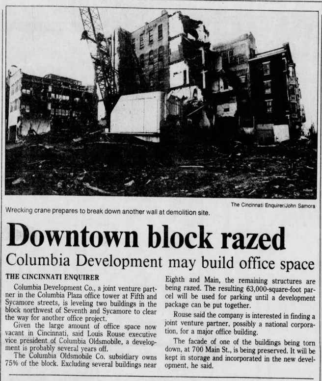
Given the demolition of multiple surrounding buildings in 1987, this means a block that once had many building types, in various states of repair, with many landlords, charging rent at multiple price points, will now be mostly a single unit controlled by a single entity for the foreseeable future. And that type of consolidation is what has been happening to our economy in a nutshell.
Article from the January 14, 1987 Cincinnati Enquirer. The proposed office building never happened and the area remains a parking lot.
I believe the same granularity argument applies to preserving the Davis Furniture building on Main Street in Over the Rhine as well.*
*As with everything, though, and for the sake of consistency with my other blog posts, the granularity argument needs to be balanced with other concerns. For example, I would not oppose a new development on an empty lot solely on the basis of its being coarse-grained: Cincinnati needs to add people, and most new development falls into the coarse grained category. I also would not, for neighborhood affordability’s sake, be in favor of preserving a something like single story garage if 30 condos could fit onto the site; but these are considerations on a case-by-case basis best left for other blog posts.
Elon Musk had a curious series of tweets over the weekend about how he was going to get involved in tunnel boring. Why would a man who dreams of Mars want to get into such a “boring” business? I’m speculating on what might be Musk’s motives here, but here’s an intriguing possibility. Networks of tunnels, if they were built to electric-vehicle-only specifications, could be the “killer app” that could lead the masses to finally ditch the internal combustion engine and switch over to electric vehicles (the main product of Musk’s more well known company, Tesla Motors.)
Despite the high-profile breakdown of the “Big Bertha” tunnel boring machine underneath Seattle, the cost of building tunnels is actually decreasing due to advances in tunnel boring machine technology.Furthermore, a tunnel built for the exclusive use of electric vehicles would be cheaper to build, operate, and maintain than one built to accommodate gas powered vehicles. Since electric vehicles have no exhaust, the specifications for ventilation equipment would be a less demanding for an electric vehicle-only tunnel,* and it would cost less to operate over time.
Built underneath the hillsides of a city like Los Angeles or Cincinnati, these tunnels would allow electric vehicle owners to bypass the traffic, stoplights, and other “friction” of the streets above. At least before the electric vehicle market matures and the “induced demand” phenomenon kicks in, one would have the sense of traveling between one tunnel endpoint to another in a Super Mario Brothers warp-zone-like fashion. The right to use the tunnels would give consumers a reason to purchase electric vehicles beyond environmental altruism or the always-changing system of tax credits from the government.
Electric vehicle exclusivity of the tunnels could be maintained by installing red-light style cameras that could get the license plate of any non-electric vehicle attempting to use the tunnels, to be followed up with a hefty fine delivered in the mail. (The ventilation system would still have to be large enough to handle the fumes from one or two scofflaws at a time. Additionally, it could be built robustly enough to accommodate the occasional gasoline-powered emergency vehicle.)
Since the market share of electric vehicles is at such a low level today, and they are mostly available only to the well-to-do, tunnel construction could be justified by accommodation of mass transit. Electric buses (or the occasional streetcar) could have exclusive, dedicated lanes in the tunnels alongside lanes for private vehicles. The dual-use nature of the tunnels could give the concept more political support than if the tunnels were for either mass transit or private vehicles alone. Tunnel construction costs could also be offset by encouraging Transit-Oriented Development near the portals of the tunnel to grow the tax base.
*NOTE: Another factor in tunnel ventilation design is the emergency management of smoke and fumes in case of fire inside of the tunnel. Electric-vehicle-only tunnels would still of course have to design for this, so I would need a subject matter expert to determine how significant the up-front equipment savings would be if tunnels were designed to be electric-vehicle-only.
Workers during the repair of the “Big Bertha” tunnel boring machine underneath Seattle in the spring of 2015. Although the Big Bertha incident was a high-profile setback, tunnel boring machine technology continues to improve.
Some simple fixes could remove physical and psychological barriers between Downtown, Over-the-Rhine, and the West End.
In old black and white aerial photographs of Cincinnati, the “basin” area is a teeming metropolis, its densely packed buildings the equal of any city on the East Coast. Downtown, Over-the-Rhine, and the West End all blended into one contiguous urban form. That all changed in the 1950’s and 1960’s with the widespread destruction of the West End for the construction of I-75 and the “Queensgate” industrial park, which up until that point did not exist. Kenyon-Barr, an expansive African American neighborhood with exquisite architecture, was tragically razed and thousands of families were displaced (more on that here, here, and alsohereif you enter the search term “Kenyon Barr.”) This kind of widespread destruction was known by the misnomer of “urban renewal” and was actually quite typical in American cities at the time. Urban renewal and its associated policies were what Jane Jacobs railed against in her 1961 classic “The Death and Life of Great American Cities.”
Today, while I-75 forms a formidable barrier between Downtown and Queensgate, the northern portion of the West End still exists thanks to a dogleg in the highway, and abuts northern Downtown and Over-the-Rhine. However, there are several other flaws in the urban form that conspire to cut the West End off from Downtown and OTR, both physically and psychologically. Let’s examine some of these issues near the West End’s Betts-Longworth historic district.
An “urban renewal” era plan for the area behind Music Hall shows a lack of acknowledgement of the importance of pedestrian street life, which was typical of time. The plan was partially implemented.
Beginning on Central Parkway behind Music Hall, we see this extremely long double turn lane. There are never enough cars turning left onto Ezzard Charles Drive here to justify this. It should be reduced to a shortened single turn lane in order to return more space to the landscaped median and make it easier for pedestrians to cross the street (which forms the dividing line between OTR and the West End.) Some shade providing trees could also be added.
At Central Parkway and Ezzard Charles Drive, a strange parking garage/park hybrid wraps the north end of the NPR/WCET studios. This park features a shady amphitheater. But since it is not visible from the street, not many people know it’s there, let alone actually utilize it. It could be redesigned to be more open to the street.
The picture on the left shows the amphitheater. The picture on the right is the view from Ezzard Charles. A pedestrian walking by has no idea it’s there.
Also in this parking garage/park is a really cool piece of art- a horizontal clockface that is illuminated by light coming down from a circular opening above it. But once again, unless you parked at the north end of the Town Center parking garage (which is severely underutilized on weekends,) you’d have no idea it’s there.
It was not 9:28 when I took these photos.
On the top level of the garage lies this pedestrian bridge over Central Parkway to Music Hall. It is crumbling and in need of repair, replacement, or removal, which is the subject of some controversy. For context, all across the country, “skywalks” such as these are being removed in order to return pedestrian life to the streets. I’m a little bit ambivalent about the fate of this one. I don’t think that rerouting the little old ladies using it to go from the parking garage to the symphony is going to make or break street life down below. However, I question the need to spend public dollars to repair or replace it, especially considering the multi-million dollar price tags being floated around. Furthermore, as the previously discussed items demonstrate, the entire surrounding structure could use a redesign, and a new skywalk might not make sense as a part of whatever comes next.
The renovation of Music Hall is forcing the question on future of this skywalk.
One block west of Central Parkway, the backside of Town Center garage along Central Avenue creates a two-block long pedestrian “dead zone” with no storefronts or front entrances to break up the monotony. It’s a sharp contrast to the eye-catching historical building across the street.
The Town Center garage will have to be at least partially replaced for there to be any life along its side of Central Avenue.
Central Avenue itself inexplicably changes at 7th Street from a two way street into a one way street for 0.45 miles northwards through this area and then changes back into a two way street again at Ezzard Charles Drive. This provides no benefit to traffic flow and simply encourages cars to speed on the one-way portion, creating another barrier for pedestrians traveling between OTR and the West End. It also greatly and needlessly complicates navigating the neighborhood in a car. Turning this stretch of road back into a two-way street should be a no-brainer.
Why?
Another street grid oddity exists at what would be the intersection of Hopkins St. and Central Avenue. Instead of an intersection, Hopkins St. was made into a cul-de-sac years ago and a Cincinnati Parks Department maintenance garage was built along Central Avenue. The garage looks aging and underused, and forms another barrier for pedestrians going between OTR and the West End as there is no pedestrian cut-through.
This garage should be torn down to fully reconnect Hopkins Street to Central Avenue. This could also return land for development at the corner of Hopkins and Central Avenue.
South of the Town Center garage and NPR/WCET studios, the Charles Street electric substation takes up a lot of real estate. It greets the street with a blank brick wall, creating a zone devoid of human activity right at the point where Downtown, OTR, and the West End meet. Unfortunately this substation would probably be very expensive to completely move.
Charles Street substation
Finally, Court Street is the only street that travels uninterrupted all the way from the West End directly into Downtown. Unfortunately there is an asphalt sea of surface parking lots along Court Street at the boundary between the two neighborhoods. If residences and businesses were built in the place of these lots, it would go a long way towards weaving the neighborhoods together and encouraging pedestrian traffic between them.
This Court Street “parking crater” could be an opportunity to add residents.
It’s no secret that a lot of opposition to the streetcar came from the West Side neighborhoods of Cincinnati and the townships beyond. West Siders, largely descended from working class Germans from Cincinnati’s urban core, can be frugal, risk-averse, and a just a little bit stubborn. Many were skeptical of the plan to build a modern transportation system to revitalize the core, and were reinforced in this skepticism by talk radio. However, due to the current growth patterns of our metro region, the West Side needs the streetcar to deliver on its promise of growth and jobs in the core more than just about anyplace else.
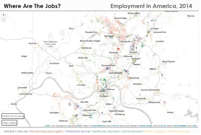
Let’s start with this job map from the website of Robert Manduca, where one dot on the map equals one job. It’s a little bit clunky to look at because the map is subdivided by census tracts of variable areas, but tells us several things. Historically we know that manufacturing and logistics jobs were concentrated in the Mill Creek Valley in close proximity to the West Side. Some of these jobs are still visible on the map. But the map also shows that these jobs (in red) have spread to areas to the north and northeast of our metro region along I-275 and beyond, with another cluster of jobs growing up around the airport in Northern Kentucky. On the map we can also see professional services jobs (in blue) have spread from Downtown Cincinnati to Blue Ash, and retail, hospitality, and other services (in yellow) have formed clusters around Kenwood Towne Center and in Mason. Uptown Cincinnati remains dominant in Healthcare, Education, and Government jobs (in green.)
What drove the spread of jobs (especially in manufacturing and logistics) to the north and northeast? The interstate highways tell the story (map on the left below.) I-71 to the Ohio state capital of Columbus and I-75 to the engineering and manufacturing center of Dayton travel parallel paths through the north of our metro, forming a corridor with great highway access. Meanwhile, to the west, we see that I-275 takes on an oblong shape, being stretched far out in order to cross the state line into Indiana. This was done in order to be able to draw on Indiana funding for the construction of the loop, but it had consequences for development patterns on the west side.
Image on left shows the I-275 Loop as built. The image on the right shows I-275 routed much closer to the West Side, just beyond Bridgetown.
Imagine, if you will, a thought experiment: An I-275 routed much closer to the city, through western Hamilton County in Ohio (map above on the right.) It may have brought with it the sewer expansion necessary to support industry. It would have crossed over into Kentucky near the airport; it’s easy to see industrial jobs clustering around that western beltway, taking advantage of proximity to the airport and the West Side labor force. One can also imagine pass-through truck traffic actually using I-275 as a bypass instead of causing problems at the Brent Spence Bridge. However, it was not to be.
The concept of the “favored quarter” also played a role in drawing jobs to the northeast of our metro. Ben Ross explains in his book Dead End: Suburban Sprawl and the Rebirth of the American City:
What was happening here? Jobs began moving into the suburbs somewhat later than the spread of residences; it is tempting to think that the purpose of the exodus was to shorten commutes. But the jobs did not go to the same places as the homes. Population spread out fairly evenly around the cities; employment clustered where the housing was highest-priced, in what real estate experts called the “favored quarter.” Big shopping malls moved in the same direction; department stores were attracted to people who had spending power.
The most important factor in determining where a corporate office moved was proximity to the chief executive’s home and golf club. Jobs concentrated near the fanciest houses…
This clearly was the case in Cincinnati, where the wealthiest residents clustered in East Side neighborhoods like Hyde Park, Montgomery, and Indian Hill. This drove development along the I-71 corridor and concentrated office parks in Blue Ash; and even today the most successful mall in Cincinnati is Kenwood Towne Center.
And so, we see that the current suburban growth trajectories do not favor the West Side. It may be a commute of 30-40 minutes from a “deep west” neighborhood south of I-74 to the northeast corner of the metro without traffic, and there is ALWAYS traffic. Whereas older workers may secretly resent a long commute, they may rationalize it as dues that must be paid, however, younger workers do not want to put up with long commutes and, having greater freedom of choice, will choose neighborhoods that are closer to jobs. I would submit that this accounts for the success that neighborhoods like Oakley have in attracting young homebuyers.
What is to be done? Fortunately, the West Side is still close to the twin job centers of Downtown and Uptown Cincinnati. The West Side needs these centers to succeed for it to succeed. The streetcar, with its promise to add population density and businesses downtown and attract new creative and tech companies to our region, is critical to this success. West Siders should be rooting for the success of the streetcar and support its expansion to Uptown, in order to connect and merge the two job centers into a single, well tuned economic engine that will reignite demand for West Side neighborhoods.
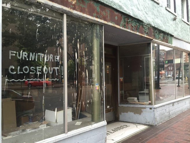
Kroger should introduce a new-to-market concept store Downtown to revitalize Court Street.
Background
Why do some people say that Downtown Cincinnati lacks a grocery store, seemingly ignoring the existence of Findlay Market and the OTR Vine Street Kroger?
While these shopping options deserve more respect, it is true that there are “gaps” in the shopping experiences offered that lead some urban residents to do their shopping at suburban grocery locations.
Findlay Market is a jewel in the Queen City’s crown. However, its very popularity & totally unique experience makes it a somewhat stressful place for weekly grocery shopping when it’s crowded. Some items, such as dry goods (paper towels & TP) aren’t available at any vendor (although that will soon change with the opening of the “Epicurean Mercantile Company.”) It also has limited hours, and may be somewhat inconvenient for CBD residents to access on foot (although that too will soon change with the opening of the streetcar.) Findlay Market will continue to do well in the future, because it offers an experience beyond the pure retail transaction.
Vine Street Kroger’s small size means it can’t offer the large deli, organic, produce and meat departments available in suburban Kroger Marketplace stores, let alone newer concepts like Kroger Bistro that offer lunch or meals-to-go. Although it is making strides in introducing new organic and specialty items, the lack of selection limits its appeal to upper middle class types moving back to the city. Vine Street Kroger is ultra-convenient to OTR residents on foot, but may be inconvenient to CBD residents who, if forced to get in their car for a shopping trip, find it just as easy to travel to the Kroger Marketplace store in the Newport Pavilion.
Vine Street Kroger does, however, provide a crucial access for OTR’s low income residents to Kroger value brands such as P$$t! and Heritage Farm. It also provides everyday neighborhood-focused retail on Vine St., which is otherwise dominated by upscale boutiques. This kind of diversity in business types adds vibrancy to the business district.
One Solution
There has been endless talk of opening a larger Kroger-branded store in the CBD. (See here, here, and here.) Most of these scenarios imply that the Vine Street Kroger will be closed.
However, Kroger’s recent expansion has brought new brand names into their portfolio, and they also have new concepts under development. The “Main and Vine” concept in Gig Harbor, WA in particular looks like a shopping experience many people are asking for in a downtown grocery store:
“From the beginning the focus of Main & Vine has always been centered on the community and fresh, local and sustainable foods, as well as mainstream grocery items available at affordable prices,” said Dann Kohl, Main & Vine’s store manager, in a statement. “Residents now have a space to explore local brands and purveyors, get inspired for their next meal, learn something new at the Event Center or meet up with friends and family in our café area.”
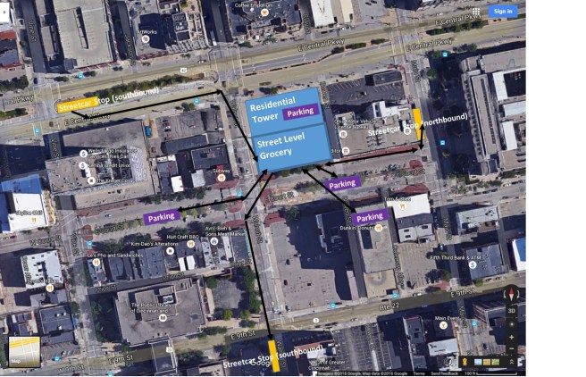
Kroger could open this concept on Court Street near their headquarters in the CBD, developing the surface parking lot bounded by Central Parkway, Walnut, and Court Streets. Since this concept could complement more than compete with the Vine Street Kroger store, they could leave the Vine Street store open for the convenience of OTR residents.
Moreover, the opening of this store could be used to revitalize retail along Court Street. There are vacant storefronts in several of the historic buildings lining Court Street, and the area is eerily quiet at night. The metered parking in the Court Street median would be very convenient to customers of such a grocery store, and would drive all-hours foot traffic past these storefronts. Additionally, nearby northbound and southbound streetcar stops serve this location.
An empty storefront on Court Street
The grocery store could also form the ground floor retail for a larger residential mid-rise or tower development, which would increase the population of the area, capitalize on demand for downtown living, and provide more potential customers.

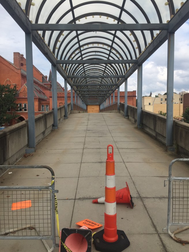
![IMG_2640[1]](https://cincinnatiideas.com/wp-content/uploads/2017/10/img_26401.jpg?w=656)
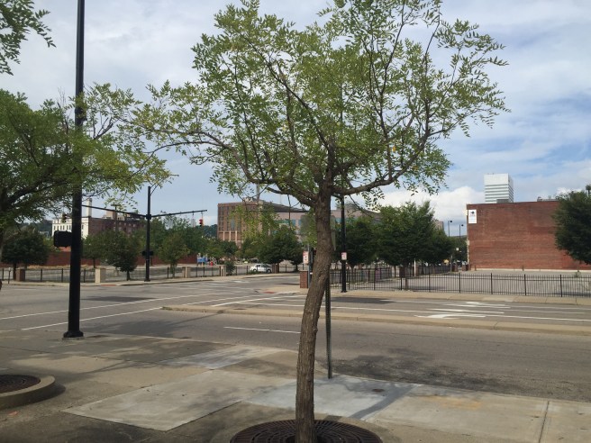
![IMG_2798[1]](https://cincinnatiideas.com/wp-content/uploads/2017/10/img_27981.jpg?w=656)