Any reasonably fair-weathered Saturday on the east side will bring out armies of joggers equipped with the latest running gear and ultra-focused lycra-clad cyclists who look like they are in training for the Tour de France. Meanwhile on the west side, these characters are nowhere to be found. Is everyone at the sports bar watching football, scarfing down chicken wings and slamming brewskies?
While much has been written about east side-west side stereotypes, I posit that there is a structural difference in the streets themselves that keeps west siders from partaking in these types of active outdoor activities. The west side is criss-crossed with arterial roads that have been built to maximize traffic throughput and vehicle speeds, that are hostile to running, cycling, and even walking as a pedestrian. More people would take part in healthy activities outside if the infrastructure was there to support it. A new shared use path for cycling, jogging and walking along the north side of Westwood Northern Boulevard in Mt. Airy Forest would be a good place to start.
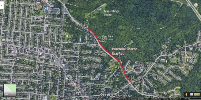
This path, as shown, would be roughly two thirds of a mile. Starting with a short sidewalk portion on the eastern end near Montana, most of the path could be wider and constructed on open parkland westward all the way west to Maple Ridge Lodge. Since the surrounding land is owned by the park and there are no natural barriers in the way, this segment of path should be relatively inexpensive to construct.
Pictured: The north side of the Boulevard features cleared land seemingly ready for a paved path.
At 1,459 acres, Mt. Airy Forest is an impressive park, but it’s easy to forget that it borders Westwood. Better pedestrian access from neighborhood streets to the amenities and trails inside of the park could change that. A shared use path along the north side of Westwood Northern would connect Maple Ridge Lodge, Doris Day Dog Park, and the McFarlan Woods trails in Area 30, while providing a path to all three for pedestrians arriving on foot from neighborhood streets like Wardall Avenue, McFarlan Woods Drive and Montana Avenue. Intersections like the one pictured below at Wardall and Westwood Northern Boulevard could add cross walks and other safety features for people crossing the boulevard to access the path.
Pictured: The intersection of Wardall and Westwood Northern has no pedestrian crossing features.
Pictured: Access to features within the park is designed with only automobiles in mind.
Thinking about the larger Cincinnati bike network, this shared path could be expanded someday via a combination of path segments and bike lanes westward through Cheviot to Harrison Avenue and eastward all the way down Westwood Northern Boulevard towards Camp Washington. (In fact, many portions of Westwood Northern Boulevard in East Westwood lack sidewalks completely on the north side, even though it’s a heavily populated area with multi-family housing structures and apartment complexes. This creates unsafe walking and road-crossing conditions along a corridor where many people must walk to bus stops.) From Camp Washington this path could link up with the new path that has been constructed on the north side of MLK Drive to access UC and the hospitals, as well as the Central Parkway bike lanes to access Downtown. In the age of the electric bike, someone might use such a bike highway to commute from the west side to these Uptown and Downtown job centers. From there, it could even connect to Walnut Hills, Wasson Way, or beyond.
