It’s all about proximity to jobs.
It’s no secret that a lot of opposition to the streetcar came from the West Side neighborhoods of Cincinnati and the townships beyond. West Siders, largely descended from working class Germans from Cincinnati’s urban core, can be frugal, risk-averse, and a just a little bit stubborn. Many were skeptical of the plan to build a modern transportation system to revitalize the core, and were reinforced in this skepticism by talk radio. However, due to the current growth patterns of our metro region, the West Side needs the streetcar to deliver on its promise of growth and jobs in the core more than just about anyplace else.
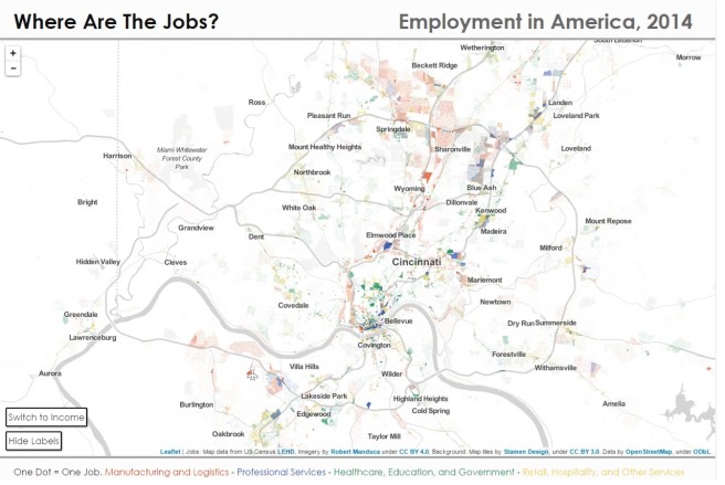
Let’s start with this job map from the website of Robert Manduca, where one dot on the map equals one job. It’s a little bit clunky to look at because the map is subdivided by census tracts of variable areas, but tells us several things. Historically we know that manufacturing and logistics jobs were concentrated in the Mill Creek Valley in close proximity to the West Side. Some of these jobs are still visible on the map. But the map also shows that these jobs (in red) have spread to areas to the north and northeast of our metro region along I-275 and beyond, with another cluster of jobs growing up around the airport in Northern Kentucky. On the map we can also see professional services jobs (in blue) have spread from Downtown Cincinnati to Blue Ash, and retail, hospitality, and other services (in yellow) have formed clusters around Kenwood Towne Center and in Mason. Uptown Cincinnati remains dominant in Healthcare, Education, and Government jobs (in green.)
What drove the spread of jobs (especially in manufacturing and logistics) to the north and northeast? The interstate highways tell the story (map on the left below.) I-71 to the Ohio state capital of Columbus and I-75 to the engineering and manufacturing center of Dayton travel parallel paths through the north of our metro, forming a corridor with great highway access. Meanwhile, to the west, we see that I-275 takes on an oblong shape, being stretched far out in order to cross the state line into Indiana. This was done in order to be able to draw on Indiana funding for the construction of the loop, but it had consequences for development patterns on the west side.


Image on left shows the I-275 Loop as built. The image on the right shows I-275 routed much closer to the West Side, just beyond Bridgetown.
Imagine, if you will, a thought experiment: An I-275 routed much closer to the city, through western Hamilton County in Ohio (map above on the right.) It may have brought with it the sewer expansion necessary to support industry. It would have crossed over into Kentucky near the airport; it’s easy to see industrial jobs clustering around that western beltway, taking advantage of proximity to the airport and the West Side labor force. One can also imagine pass-through truck traffic actually using I-275 as a bypass instead of causing problems at the Brent Spence Bridge. However, it was not to be.
The concept of the “favored quarter” also played a role in drawing jobs to the northeast of our metro. Ben Ross explains in his book Dead End: Suburban Sprawl and the Rebirth of the American City:
What was happening here? Jobs began moving into the suburbs somewhat later than the spread of residences; it is tempting to think that the purpose of the exodus was to shorten commutes. But the jobs did not go to the same places as the homes. Population spread out fairly evenly around the cities; employment clustered where the housing was highest-priced, in what real estate experts called the “favored quarter.” Big shopping malls moved in the same direction; department stores were attracted to people who had spending power.
The most important factor in determining where a corporate office moved was proximity to the chief executive’s home and golf club. Jobs concentrated near the fanciest houses…
This clearly was the case in Cincinnati, where the wealthiest residents clustered in East Side neighborhoods like Hyde Park, Montgomery, and Indian Hill. This drove development along the I-71 corridor and concentrated office parks in Blue Ash; and even today the most successful mall in Cincinnati is Kenwood Towne Center.
And so, we see that the current suburban growth trajectories do not favor the West Side. It may be a commute of 30-40 minutes from a “deep west” neighborhood south of I-74 to the northeast corner of the metro without traffic, and there is ALWAYS traffic. Whereas older workers may secretly resent a long commute, they may rationalize it as dues that must be paid, however, younger workers do not want to put up with long commutes and, having greater freedom of choice, will choose neighborhoods that are closer to jobs. I would submit that this accounts for the success that neighborhoods like Oakley have in attracting young homebuyers.
What is to be done? Fortunately, the West Side is still close to the twin job centers of Downtown and Uptown Cincinnati. The West Side needs these centers to succeed for it to succeed. The streetcar, with its promise to add population density and businesses downtown and attract new creative and tech companies to our region, is critical to this success. West Siders should be rooting for the success of the streetcar and support its expansion to Uptown, in order to connect and merge the two job centers into a single, well tuned economic engine that will reignite demand for West Side neighborhoods.