Description
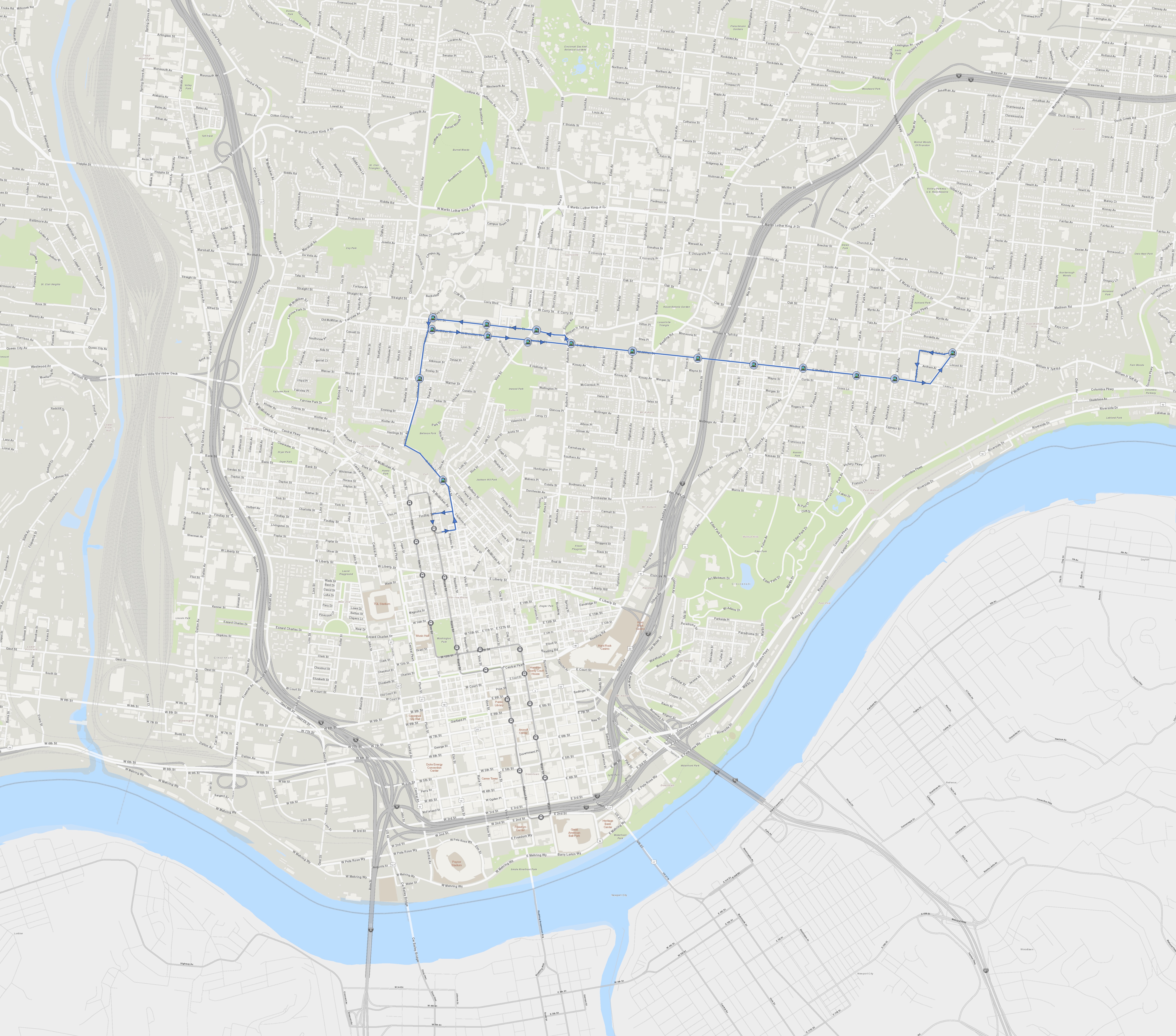
A new streetcar route, beginning at Findlay Market, uses W Clifton Ave. to reach the University of Cincinnati, and then connects to nearby Uptown neighborhoods and Walnut Hills, expanding student housing opportunities and access to groceries and other businesses.
| East Walnut Hills bound Stops | Downtown bound Stops |
| Findlay Market Race St. (existing stop; passenger can transfer from existing route) | Taft and Woodburn |
| W. Clifton and Vine | McMillan and Ashland |
| Warner and W. Clifton | McMillan and Park |
| McMillan and W. Clifton | McMillan and Gilbert |
| McMillan and Ohio | McMillan and Kenton |
| McMillan and Vine | McMillan and Essex |
| McMillan and Auburn | McMillan and Highland |
| McMillan and Highland | McMillan and Auburn |
| McMillan and Essex | Taft and Vine |
| McMillan and Kenton | Calhoun and Ohio |
| McMillan and Gilbert | Calhoun and W. Clifton |
| McMillan and Park | Warner and W. Clifton |
| McMillan and Ashland | W. Clifton and Vine |
| Taft and Woodburn | Findlay Market Race St. (existing stop; passenger can transfer to existing route) |
Route Highlights
Findlay Market anchors one end of route providing access to fresh food and a transfer point to the existing streetcar line. Using the track spur on Elder Street, the route travels up Vine to W. Clifton Ave. It goes up the steep W. Clifton Ave. hill through an area of Clifton Heights dense with student housing. It then turns right onto McMillan Ave. and heads east with stops serving the University of Cincinnati and business district. A stop at Vine Street provides access to a major bus transfer point. It continues along McMillan connecting Mt. Auburn and Corryville and their housing opportunities. East of I-71 it travels through the heart of Walnut Hills connecting its businesses and housing to the University economy. Finally it reaches East Walnut Hills and loops back around using Woodburn, Taft, and Bell, with a stop at the southern end of the East Walnut Hills business district. On the return journey, it travels west along McMillan (McMillan Ave. is reconfigured into a two way street to accommodate this.) At Auburn Ave. it turns right and then left on Taft, with a stop providing access to groceries at Kroger. It then travels west on Calhoun along the bustling southern border of the University of Cincinnati before turning left on W. Clifton Ave. and heading back to Findlay Market.
Strengths
The route passes by many sites that could support additional housing as well as sites where development projects are already planned or underway.
The route serves a already very dense area south of the University under continuous demand for development that is at its limit with automobile traffic. The streetcar could help spread out housing demand to the surrounding neighborhoods while providing a transportation alternative.
Connects neighborhoods to fresh food at Findlay Market and Kroger.
The route makes use of the existing Findlay Market Race St. stop and the existing track spurs at Findlay St. and Elder St.
The route is separate from the existing downtown route, isolating any problems that may occur and allowing flexibility in levels of service. The route would also have strong demand on its own serving the dense Uptown area.
The route passes close by the existing Maintenance and Operation Facility allowing efficient operations.
Could be expanded northwards along Woodburn through Evanston to Xavier University and Wasson Way.
Challenges
According to a previous study, W. Clifton Ave. gradient steepness is right around the limit for supporting a streetcar route, and the gradient may need to be confirmed with streetcar manufacturers.
Warner and W. Clifton may be too steep to support a streetcar stop.
Requires two way conversion of McMillan Ave. between Auburn Ave., and I-71 ramp.
May require additional service track on Findlay Street to efficiently return to Maintenance and Operation facility.
Related Concepts
Works with Streetcar to Fairmount and Streetcar to Northside concepts.
