This is a concept that extends the streetcar into a light rail-style line to Uptown and beyond by traveling through a two part tunnel underneath Mt. Auburn. It could provide a faster connection between Downtown and UC than going up the Vine Street hill in mixed traffic as currently planned for future phases of the streetcar.

The streetcar tracks would be extended north through OTR along Main and Walnut streets, crossing Liberty and entering a tunnel underneath Mt. Auburn at the foot of the hill, in the vicinity of Mulberry St. Traveling northward, the tunnel and tracks would momentarily daylight in the steep ravine behind Christ Hospital for a Christ Hospital stop. This would probably involve building some kind of plaza/elevator infrastructure to access the hospital itself, and to make an easier pedestrian connection to Auburn Ave. The tracks would then enter a second tunnel bound for UC. A station servicing Clifton Heights would have to be underground; perhaps it could be designed so that it has entrances off of both McMillan and Calhoun Streets, to account for the steep elevation difference between the streets there.
Somewhere north of Corry St. the tracks would daylight for good. They would have dedicated lanes along Jefferson Ave. There would be a stop at University Ave. servicing UC. The tracks would cross MLK Drive, and there would be a stop in the park-like area at Goodman and Vine St. This stop would serve the VA, the EPA, and the Cincinnati Zoo. This stop would be about a third of a mile away from the entrance to the Zoo. For reference, that is roughly the distance from Great American Ballpark to Sixth Street, the distance from the entrance to Kings Island to the furthest part of their parking lot, or two thirds of the walk across UC’s campus. This represents a compromise that serves the Zoo, but also keeps the shape of the line relatively direct for end-to-end travelers. The track would then head east on Goodman Ave to Eden Ave.
At Eden Ave. and MLK Drive, the tracks would exit the roadway to a dedicated off-street right of way just to the north of MLK Drive, and follow it east. An elevated bridge structure and/or series of underpasses could be built along this section to achieve grade separation at cross streets along this stretch. This would allow for a higher average speed and keep the train out of vehicle traffic through a stretch of hilly terrain that could be treacherous in bad weather. There would a stop at the University/Children’s/VA Hospital Campus, and also a stop at Reading Rd., where Uptown Consortium is assembling properties for a research/biotech hub.
At the MLK interchange with I-71, the tracks would make a left hand turn and follow the highway north, mostly using the existing rail right of way west of the highway. It would mostly have dedicated right of way through this corridor. A stop at Blair Ct. in Avondale could be coupled with a new bridge extending over I-71 to connect directly to Walnut Hills High School. There could be some Transit Oriented Development along the tracks & highway in this corridor. The final stop would be at Xavier University by the University Station development, serving Norwood and Evanston.
The line would be well positioned for future extension along Wasson Way to serve Oakley, Hyde Park, Fairfax, and Mariemont. In the meantime it would be connected to the Wasson Way hike and bike trail. A separate light rail branch could extend northward from Xavier to serve neighborhoods along I-71.
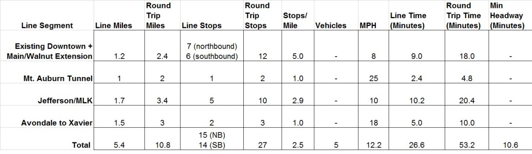
Here is my estimate of travel times along segments of the line. (Timing depends on my average MPH guesstimates.) I estimate the line could be traversed end to end in roughly 27 minutes.
The Mt. Auburn Tunnel has been part of plans for a regional transportation network dating back decades. The idea to route the streetcar through the Mt. Auburn Tunnel in lieu of using Vine Street to go Uptown has been recently forwarded by John Schneider and Jules Rosen. In this post I have added my own details (stops, travel times) to what is essentially their plan.
This concept could be paired with a light rail-style line to Northside for the beginnings of a regional light rail system.
